


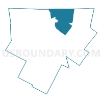
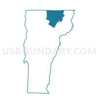
Derby Voting District, Orleans County, Vermont
About
Outline

Summary
| Unique Area Identifier | 680847 |
| Name | Derby Voting District |
| County | Orleans County |
| State | Vermont |
| Area (square miles) | 57.60 |
| Land Area (square miles) | 49.12 |
| Water Area (square miles) | 8.48 |
| % of Land Area | 85.27 |
| % of Water Area | 14.73 |
| Latitude of the Internal Point | 44.95200300 |
| Longtitude of the Internal Point | -72.13649470 |
Maps

Graphs
Select a template below for downloading or customizing gragh for Derby Voting District, Orleans County, Vermont


Neighbors
Neighoring Voting District (by Name) Neighboring Voting District on the Map
- Brownington Voting District, Orleans County, VT
- Charleston Voting District, Orleans County, VT
- Coventry Voting District, Orleans County, VT
- Holland Voting District, Orleans County, VT
- Morgan Voting District, Orleans County, VT
- Newport Voting District, Orleans County, VT
- Newport City Voting District, Orleans County, VT
Top 10 Neighboring County Subdivision (by Population) Neighboring County Subdivision on the Map
- Derby town, Orleans County, VT (4,621)
- Newport city, Orleans County, VT (4,589)
- Newport town, Orleans County, VT (1,594)
- Coventry town, Orleans County, VT (1,086)
- Charleston town, Orleans County, VT (1,023)
- Brownington town, Orleans County, VT (988)
- Morgan town, Orleans County, VT (749)
- Holland town, Orleans County, VT (629)
Top 10 Neighboring Place (by Population) Neighboring Place on the Map
Top 10 Neighboring Elementary School District (by Population) Neighboring Elementary School District on the Map
- Derby School District, VT (4,621)
- Newport City School District, VT (4,589)
- Newport Town School District, VT (1,594)
- Coventry School District, VT (1,086)
- Charleston School District, VT (1,023)
- Brownington School District, VT (988)
- Morgan School District, VT (749)
- Holland School District, VT (629)
Top 10 Neighboring Secondary School District (by Population) Neighboring Secondary School District on the Map
- North Country Union High School District 22, VT (18,017)
- Lake Region Union High School District 24, VT (7,382)
Top 10 Neighboring State Legislative District Lower Chamber (by Population) Neighboring State Legislative District Lower Chamber on the Map
Top 10 Neighboring State Legislative District Upper Chamber (by Population) Neighboring State Legislative District Upper Chamber on the Map
Top 10 Neighboring 111th Congressional District (by Population) Neighboring 111th Congressional District on the Map
Top 10 Neighboring Census Tract (by Population) Neighboring Census Tract on the Map
- Census Tract 9516, Orleans County, VT (4,313)
- Census Tract 9512, Orleans County, VT (2,850)
- Census Tract 9515, Orleans County, VT (2,562)
- Census Tract 9519, Orleans County, VT (2,424)
- Census Tract 9511, Orleans County, VT (2,401)
- Census Tract 9514, Orleans County, VT (2,027)
- Census Tract 9513, Orleans County, VT (1,771)
Top 10 Neighboring 5-Digit ZIP Code Tabulation Area (by Population) Neighboring 5-Digit ZIP Code Tabulation Area on the Map
- 05855, VT (7,170)
- 05860, VT (2,557)
- 05829, VT (2,003)
- 05857, VT (1,540)
- 05830, VT (1,502)
- 05872, VT (789)
- 05853, VT (711)